This adventurous while also indulgent tour is the best of both worlds with regard to what the Salta region offers (or even 3 worlds if you consider the city of Salta itself). Top class vineyards and the highest altitude wine in the world, plus the beautiful and rugged spectacle of the Puna landscape – enjoy that “middle-of-nowhere” feeling!
You will travel in a private vehicle, with a native English-speaking driver / guide, through jaw-dropping scenery where your camera will never get a rest. We have designed this tour so that you can acclimatize a little more easily while doing the circuit to relax and fully enjoy the incredible views.
Day 1 – Arrival in the city of Salta
Salta is a lovely colonial town in the Northwest of Argentina with the best-conserved Hispanic architecture in the country, surrounded by the foothills of the Andes and lush green valleys. When you arrive at Salta airport (SLA) your guide will meet you for a private transfer to your hotel in the city. You have a range of hotel options in Salta – ask us to give you the options.
After you check-in we will take you around Salta on a gentle walking tour to visit some of the main attractions. Firstly we will visit the main square (Plaza 9 de Julio) and view some of the historical colonial buildings around town, such us the main Cathedral, the very photogenic San Francisco Church and the San Bernardo Convent.
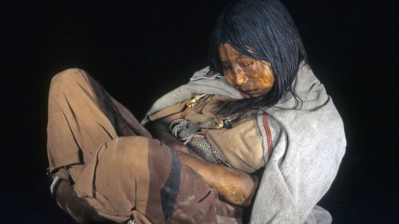
Then, we’ll take a look around the MAAM Museum of High Mountain Archeology to enjoy the very interesting items on display. The museum is located on the main square and is famous for the best preserved Inca mummies ever found. A 1999 expedition on the 22,000 ft Llullaillaco Volcano unearthed three child mummies sacrificed and buried in the ice by Inca nobility.
BBC report on the Children of Llullaillaco
These 500-year-old Inca children are preserved in climate controlled chambers, at a specific temperature and under special lighting so they do not decay any further after being extracted from their icy ceremonial graves. Depending on the time open to us we should be able to add more visits according to your specific interests so please let us know what they are so we can advise you.
We will lastly ascend the San Bernardo Hill for some great views over the city before taking you back to your hotel. In the evening there is the chance to enjoy dinner at one of the traditional Peñas in Salta, there are a number to choose from so ask us about them so we can advise and set the night up for you.
Day 2 – Salta | National Park Los Cardones & Cachi
Distance: 122 km on paved roads / 30 km on gravel roads.
Altitude: Highest point 3457 m – Cachi 2531 m – Estimated driving time: 3 hours
The Calchaquí Valleys are considered very special in the winemaking world and you will get to know them quite well over the next few days. Today we will travel through the countryside seeing many areas of tobacco-growing plus other crops that are produced in the fertile fields of Salta’s agricultural region to reach our first route “to the clouds”, the Cuesta del Obispo.
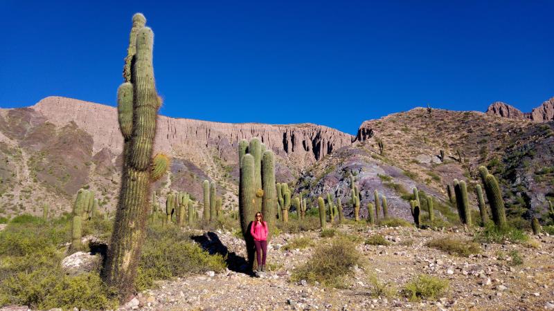
Along the 33 km of twisting mountain road we will have great views of the area before crossing a pass at 3457 metres above sea level and before entering the Cardones National Park. Cardones are the huge Cacti you can see in the photo below, they give you a great chance for amusing Cacti selfies!
Arriving in Cachi, a delightfully rustic town at the edge of the Salta wine region, we will visit the 2 vineyards of Isasmendi and Miraluna. We may get some lunch before, during or after the visits, depending on our and the winery schedule and according to how hungry you are. This is one of the huge advantages of a private tour and vehicle, we can adjust to suit local factors and you of course. Returning to the town well fed and slightly merry from wine tasting you will check-in to your lodging in the town and then have the evening free to wander the laid back plaza and maybe shop for souvenirs.
Day 3 – Cachi to Molinos | Capital of High Altitude Wine
Distance: 70 km on gravel roads.
Altitude: Highest point 2.600 m – Estimated driving time: 2 hours.
Upon arriving in the Molinos region after Cachi we will visit the Bodega Tacuil. With its roots set back in 1810 this little winery is operated by the Dávalos family to produce the unique wines of their family which today stem from grapes imported from France. Due to the unique characteristics of the soil, climate, mountainside locations and altitude (with some of the vines being grown at 2.597 meters above sea level) the grapes have greater concentrations of tannins which make them ideal for wines of unique personality and high quality. We will enjoy a lunch at this winery or at the next, depending on timings and hunger levels.

The afternoon sees us visit the icon of your high altitude wine tour at Bodega Colomé which is the realization of a dream for the owners to develop wines in the highest vineyards in the world. The winery is part of Hess Family Estates, a family owned company from Switzerland which boats wineries in the United States, South Africa and Argentina. The Hess Family has specialized in the production and marketing of high quality wines as well as art projects, gastronomy and now tourism. We will visit the wine cellar in the afternoon and then we will have the chance to experience the James Turrell Museum which will surprise you in a number of ways. We will spend the night in the very laid back village of Molinos again to recover from the days exertions. We will be staying at the historic and beautiful Hacienda de Molinos hotel, subject to space for your dates of course.
*Please Note: The James Turrell Museum is closed on Mondays. The sky show does not open during Summer (rainy season January/February).
Day 4 – Cafayate | Winemaking Traditions and a Unique Terroir
Distance: 24 km on paved roads. 92 km on gravel roads.
Altitude: Highest point 2.300 m – Cafayate 1.683 m – Estimated driving time: 3 hours.
When traveling between the towns of Molinos and the wine capital of Cafayate we will pass many little villages populated by small-scale wine makers and farmers. We will find ourselves travelling through the desert of the Quebrada de las Flechas among canyons and narrow rock formations making beautiful shapes and great photo opportunities. In Cafayate the semi-desert climate, the temperature range extremes between day and night and the soil types (low in organic matter) define a unique Terroir, specific to this small region.
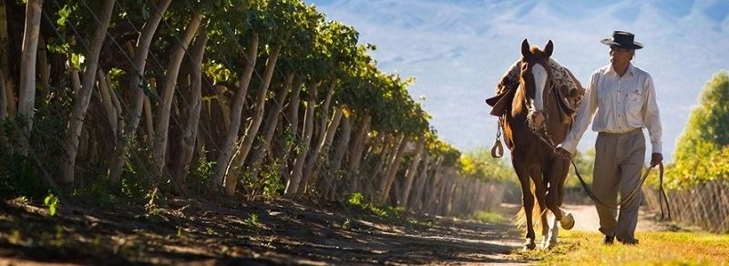
Depending on your guides knowledge and your preferences we will visit a number of vineyards and wineries during the day. There are so many places in the Cafayate area that you can just leave the order and number of visits to us but one thing is for sure, you will be very well-informed on Cafayate wines and enjoy a number of tastings and a great lunch at the Patios de Cafayate hotel or similar.
In the evening you will be free to wander the atmospheric main square of Cafayate, eat and drink a little more and watch local people do what they do. Depending on timings you may be able to visit the excellent wine museum in the town, not far from your hotel.
Day 5 – Free Day for Options in Cafayate
Today you will have options. You can choose something active such as horse back riding on a local Estancia or in the desert or you could mountain bike in the surrounding mountains or among the vineyards for example. There is a short hike to a nearby set of waterfalls you could try also. Or you could take it easy and try more wine tastings on vineyards and just kick back in the plaza. The choice is yours and we spend the night in Cafayate again.
Day 6 – Quilmes, Hualfin, Santa María and El Peñon
Distance: 200 km on paved roads – 50 km on gravel roads
Altitude: Highest point 4100 m – Estimated driving time: 5 hours.
Today we gear up for a few days in the great outdoors where you will have that “middle-of-nowhere” feeling that is so difficult to find these days in a world so well-connected. The ruins at Quilmes and the Pachamama museum are to be visited before we leave the paved roads behind. These visits will give you a feel of the ancient ancestry of the region dating back centuries before the Spaniards arrived.
The photogenic road from El Peñón which joins the fabled Argentine Route 40 is a 150km-long yellow expanse of Paja Brava (hardy high-altitude grass), white lagoons and a deserted narrow canyons with scattered green vegetation. Climbing steadily higher the opportunities to get out of the vehicle and take great photos become more and more frequent, with landscapes and colors changing. Our overnight stop will be in the tiny settlement of El Peñon.
Day 7 – El Peñón | Campo de Piedra Pómez Laguna Grande
Distance: 130 or 200 km on dirt, gravel and salt tracks.(Depending on the season).
Altitude: Highest point 4200 m – El Peñón 3400 m – Estimated driving time: 3 to 6 hours.
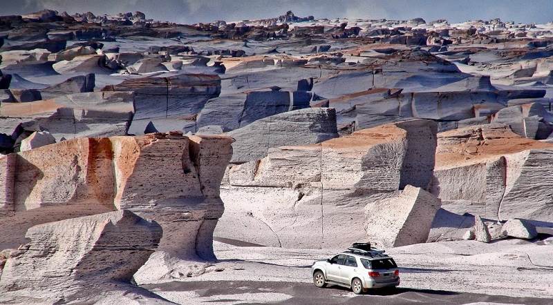
Program from October to April (austral spring / summer season): Morning: Visit to the Natural Reserve Campo de Piedra Pómez, a strange and stunning landscape carved into the rock that gives the area its name. Piedra Pomez means Pumice Stone.
Pumice is produced from volcanic explosions which are often so powerful that the visual effect would have been similar to the mushroom cloud produced by a nuclear detonation. The cloud then spreads ashes and debris over a wide area giving birth to unusual rock formations with many holes formed by the escape of gases during cooling.
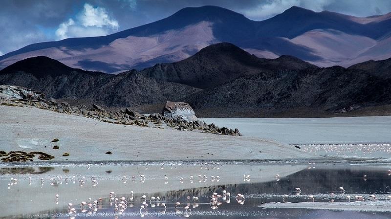
Afternoon: Visit to Laguna Grande RAMSAR site, a place of unique natural beauty. This salt lake sits at an altitude of 4150 meters above sea level. During winter the water freezes solid, but when spring arrives the area welcomes the largest colony of Puna flamingo, also called Small Parina (Phoenicpterus Jamesi). More than 19,000 birds visit the area which is around 25% of the known total population and your Puna tour offers a great chance to see then close up. Laguna Grande is a summer stop for the Andean Flamingo (Phoenicpterus andinus) and also a common nesting site of the Southern Flamingo (Phoenicopterus chilensis).
Day 8 – Oasis Antofallita and Antofalla, Vega Colorada and Calalaste
Distance: 340 km on dirt tracks and salt roads.
Altitude: Highest point 4.500 m – El Peñón 3.400 m – Estimated driving time: 6 hours.
Antofalla is a spectacular example of a how vegetation can flourish in a Puna Oasis and is set in the middle of a high altitude desert thanks to the presence of a natural pure-water spring. In this seemingly barren place a number of Poplar, Molle and Willow trees grow with various crops tended by this very isolated community.
Antofalla, together with Antofagasta and Santa Rosa, were important waypoints for the many llama caravans that used to connect this part of the Andes with the Atacama oasis and indeed Antofalla is still inhabited by a tiny community of 60 people. We will stop for lunch here before traveling across the reflective surface of the salt lake.
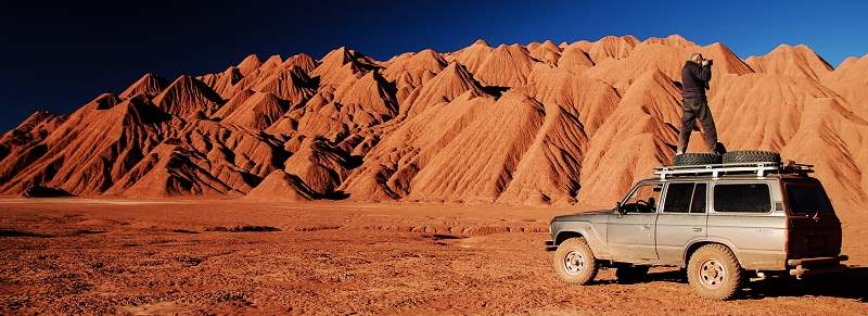
We will now be traveling above 4200 meters affording impressive views of the Antofalla Volcano (6400 mts), the green and gold fields of Vega Colorada, home to herds of llamas, suris (the Andean ostrich), wild donkeys and vicuñas. The valley of Calalaste, just a few kilometers away from Vega Colorada is the best spot to find wild camelids. Antofagasta de la Sierra was once the largest oasis on the route connecting this side of the Andes with the oasis of San Pedro de Atacama in Chile. Today it is a village of around 2000 people who stoutly cling to their ancient traditions and culture.
Day 9 – Explore Tolar Grande | Salar de Río Grande
Distance: 130 km on paved roads. 180 km on dirt tracks and salt roads.
Altitude: Highest point 5.200 m – Tolar Grande 3.500 m – Estimated driving time: 7 hours.
On your Puna tour today we will go exploring literally in the middle of nowhere. Mina Casualidad was a mining town located in one of the most remote places on Earth. This outpost is located very near to the border with Chile and is surrounded by some of the highest volcanoes on the planet. Some 3000 people used to live here with the miners working at around 5200 meters so we can only imagine how tough that life was! The mine was shut down by the army during the 1970’s and today Mina Casualidad is a true Ghost Town.
Caipe was the old railway station where the mineral from the mine was loaded and then transported to Salta. From the now abandoned station we get a great panoramic view of the huge Salar de Arizaro. In the afternoon on our way back to Tolar Grande, hopefully with the perfect light from sunset, the views of the Puna will be outstanding.
Note: The road access to some locations may be closed in winter in case of heavy snow.
There are other options for visits today also, and this will be decided by your guide depending on local conditions, plus of course your personal choices where we can accommodate them.
For example the morning can be dedicated to the exploration of the areas surrounding Tolar Grande. The Ojos del Mar are blue holes in the middle of the white salt lake where in 2009 researchers discovered a huge colony of living stromatolites.
The Tolar Grande area offers the chance to make some interesting short hikes, the best one in our opinion is to a hidden sand dune in the middle of the desert. From the top of this dune the hiker will be rewarded with a 360° panoramic view from the sacred Macon mountain to the Llullaillaco Volcano where the Inca children which can be viewed in the MAAM museum in Salta were found. It is also a perfect place for meditation taking advantage of the silence and majesty of nature.
Day 10 – From El Peñon area to Salta via S.A. de los Cobres & Quebrada del Toro
Distance: 100 km on paved roads / 250 km on dirt tracks and gravel roads.
Altitude: Highest point 4.500 m – Tolar Grande 3.500 m – Estimated driving time: 6 hours.
We will drive across this natural wonder, an absolute must for photographic safari enthusiasts. Tolar Grande lies at the border of a giant low-lying salt flat, the Salar de Arizaro. This is one of the biggest salt flats in the world and from the tiny old railway village dating back to the 1940s there is a unique view over the western ridge of the mountain range and volcanoes rising to more than 6000 meters above sea level.
The Abra Chorrillos pass will be our highest point today and here we will learn about the Apacheta and its cultural importance for the Andean civilizations. After the crossing of the geologically dying Salt lake of Pocitos, an exciting 3-hour drive in very wild and unspoilt landscapes begins. The Labyrinth Desert is a 10 million–year old fossil dune desert formed from clay and gypsum crystals.
We start to drop off the high desert and plung down towards the lush Lerma Valley below. In less than 100km of distance this road switchbacks and falls from over 4000 meters at the Abra Blanca Pass to Salta at 1200m. What happens when we get back to “civilization” depends on your onward plans, you might be taking a flight out tonight, or more likely you can have us book you another night in the city. One thing is certain, you will have had one great outdoors adventure!
